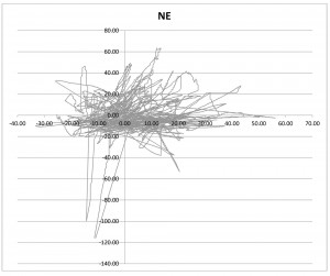
I started to experiment with GPS positional error. I placed a Trimble Lassen IQ receiver in the shadow of my house. Most the the satellites vehicles (SV) in the south are masked. I logged position data all night and loaded the data into Excel. I then converted the lat/lon data to relative Northing and Easting based on a position dictated by the average lat and the average lon. The results were rather shocking.Note that the variation in position varies by 80 feet east/west and 180 feet north/south. The northing error being larger makes sense in that I have a poor distribution of SVs south. What was surprising was the magnitude of the error. At over 100 feet, there is no way GPS alone can be used to navigate an RC car around a building that is masking a significant number of SVs.
It is also interesting to see a few radial spikes in these plots. These are not solitary outliers, but rather 20-60 seconds of bad data. I could see being able to account for a few spikes, but 60 seconds of crud is longer than I want to take to drive around the whole building!
The next step is to correlate this data to number of SVs visible and the orientation of the SVs.
